
My Home Anandam Map
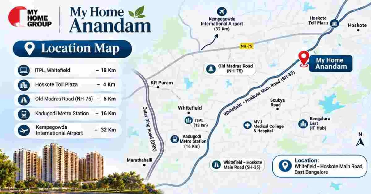
My Home Anandam Map helps homebuyers locate the upcoming residential development along the Whitefield–Hoskote corridor in East Bengaluru. The project is situated near Kattamanallur, Sannatammanahalli and Konadaspur, with access to the Bengaluru–Tirupati Highway and nearby connecting roads.
Understanding the project's location, map coordinates and road access can help buyers plan site visits and evaluate its connectivity with different parts of East Bengaluru. The location is particularly relevant for people looking at residential developments along the Whitefield–Hoskote Road.
My Home Anandam Google Map Location
My Home Anandam is located at the following address:
Google Map Address:
2QV6+42P, Bengaluru - Tirupati Highway, Kattamanallur, Sannatammanahalli, Konadaspur, Bengaluru, Karnataka 560049.
The location falls within the developing residential belt of East Bengaluru, where road connectivity and ongoing urban development are important considerations for residents.
My Home Anandam Map Coordinates
The geographical coordinates provided for the project can be used to identify its location through navigation applications and mapping services.
Latitude: 13.0429065685
Longitude: 77.7600397011
These coordinates are useful when searching for the location directly, especially when the project name is not yet consistently available across navigation platforms.
Open the location in Google Maps:
My Home Anandam Google Maps Location
My Home Anandam Directions and Road Connectivity
Whitefield–Hoskote Main Road
The project is positioned along the Whitefield–Hoskote Main Road, which connects residential and commercial areas across East Bengaluru. This road serves as an important route for people travelling between Whitefield, Hoskote and nearby neighbourhoods.
Its location along this corridor provides access to surrounding residential communities, commercial developments and regional road connections.
SH-35 and Bengaluru–Tirupati Highway
The project location is associated with the Whitefield–Hoskote Road and the Bengaluru–Tirupati Highway. These road connections are relevant for residents travelling towards different parts of East Bengaluru and beyond.
The availability of multiple connecting roads can help commuters plan alternative routes depending on traffic conditions and their destinations.
Konadaspura Road
Konadaspura Road is another important road connection mentioned in the project location details. It provides access to nearby neighbourhoods and contributes to the road network surrounding the development.
For prospective residents, understanding the local connecting roads is useful when evaluating daily travel routes to workplaces, schools, shopping areas and other essential destinations.
How to Reach My Home Anandam
The route to My Home Anandam may vary depending on the starting location, traffic conditions and the road selected by the navigation application.
From Whitefield
People travelling from Whitefield can explore routes connecting to the Whitefield–Hoskote Main Road. The selected route will depend on their starting point within Whitefield and current traffic conditions.
From Hoskote
Travellers from Hoskote can use the connecting road network towards the Bengaluru–Tirupati Highway and the project location near Kattamanallur and Konadaspur.
From Other Parts of Bengaluru
Visitors travelling from other parts of Bengaluru should use the project coordinates or the Google Maps location link to identify the most suitable route.
Since traffic conditions may change throughout the day, it is advisable to check live navigation before beginning the journey.
My Home Anandam Location and Surrounding Area
The project is situated in East Bengaluru, along a corridor experiencing residential and infrastructure development. The surrounding area includes developing neighbourhoods and road connections that link it with established parts of the city.
Whitefield–Hoskote Road has become an important residential growth corridor because of its connection with the broader East Bengaluru region. As the surrounding neighbourhoods develop, accessibility, public infrastructure and local services will influence the area's residential suitability.
The project's location near multiple connecting roads may be relevant to residents who need to travel to different parts of the city. However, actual travel convenience will depend on road conditions, traffic congestion and infrastructure development.
Why the My Home Anandam Map Is Important for Homebuyers
Checking the location on a map helps buyers understand more than the project's address. It allows them to examine the surrounding road network, nearby neighbourhoods and potential commuting routes.
Before visiting the project, buyers may consider checking:
The exact project location using the provided coordinates
Access to Whitefield–Hoskote Main Road
Connectivity through SH-35 and Konadaspura Road
Nearby residential and commercial developments
The route from their workplace or current residence
Traffic conditions during their usual commuting hours
A physical site visit can also help buyers understand the surrounding environment, road accessibility and the development activity in the neighbourhood.